Buried beneath the oceans surrounding the continents is a naturally occurring frozen form of methane and water. Marine methane hydrate, sometimes called “fire ice” because it is literally set on fire, could melt as the climate warms, uncontrollably releasing methane (a powerful greenhouse gas) into the ocean and possibly the atmosphere.
My colleagues and I recently published research showing that more of this methane hydrate is more vulnerable to warming than previously thought. This is concerning because the hydrate contains as much carbon as all the remaining oil and gas on Earth.
Its release from the seafloor could cause oceans to become more acidic and the climate to warm further. This is a dangerous situation.
The release of large amounts of methane from similar ancient marine hydrate reservoirs has been associated with some of the most severe and rapid climate changes in Earth history. There is even evidence that the process is starting again near the US east coast.
I have been working on hydrates for over a decade, mainly investigating methane hydrate off the coast of Mauritania, West Africa. I recently took 3D seismic data to uncover oil and gas and reused it to map hydrates beneath the ocean floor. Finally, I wanted to figure out whether climate change was causing methane gas to rise to the surface.
3D seismic is the geologist’s equivalent of a doctor’s CT scan. It can cover hundreds of square kilometers and reveal hydrates several kilometers below the seafloor. Hydrate can be easily detected in these giant surveys because the sound waves created by the seismic energy source pulled by a ship are reflected from the bottom of the hydrate layers.
Searching for methane using 3D seismic images
While adjusting to a new lifestyle during the first Covid lockdown in early 2020, I reopened the much-worked dataset and began mapping again. I knew that there were many examples of hydrates that had dissolved as a result of warming since the last glacial period peaked about 20,000 years ago, and I knew that we could detect this in 3D datasets.
So what was the fate of the commodity? Did it reach the oceans and atmosphere? Because if so, that’s a major clue that it could happen again.
Around continents where the oceans are relatively shallow, the hydrate is only cold enough to remain frozen. Therefore, it is very vulnerable to any warming and therefore these areas have been the focus of most scientific research.
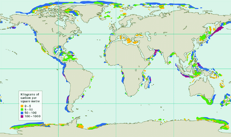
The good news is that only 3.5% of the world’s hydrate is in this fragile region, in this unstable state. Instead, most of the hydrate is considered “safe” and remains buried hundreds of meters below the seafloor in deeper waters tens of kilometers from land.
But frozen methane deep in the ocean may be vulnerable after all. In oceans and seas where the water is deeper than about 450 to 700 meters, layers of sediment containing hydrate are found. And some of it is deeply buried and geothermally heated by the Earth, so it’s right at the point of instability, even though it’s hundreds of meters below the seafloor.
Some sediment layers are permeable, creating a complex underground plumbing for gas to pass through if it is released during climatic warming. Just like keeping a football underwater, methane gas wants to be pushed upward due to buoyancy and break up 100s of meters of sediment layers.
This complex geology is marked by seven glaciers (or ice ages) and interglacial periods that have repeatedly warmed and cooled the system over the last million years.
Methane is migrating
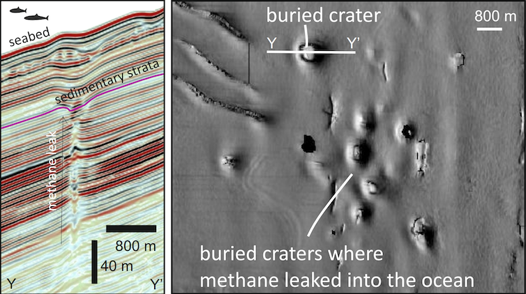
During this first lockdown of 2020, I found spectacular evidence that during warm periods over the last million years or so, methane migrated laterally, upwards, and landward toward Africa, seeping into much shallower waters. Beneath up to 80 meters of sediment, the ancient seabed contains 23 giant craters, each one kilometer wide and up to 50 meters deep, large enough to fill more than one Wembley stadium.
Seismic imaging hints at methane just beneath the craters. Similar craters form elsewhere due to prolonged or explosive release of gas on the seafloor.
These craters are not located in the sensitive area where all the attention is drawn; They are located landward in a water depth of approximately 330 meters. With the discovery in hand, I assembled an international team of scientists (modelers, physicists, geoscientists) to unravel what causes these extraordinary things to form and when they form. Our results are now published in Nature Geoscience.
We believe they formed as a result of repeated warming periods. These periods affected hydrates in the deep ocean, and the released methane migrated up to 40 km towards the continent to be ventilated beyond the shallowest hydrate beds. So in a warming world, the volume of hydrate that will be vulnerable to methane leakage is more significant than previously thought.
The positive outlook is that there are many natural obstacles to this commodity. But be warned, as we warm the planet, we expect methane from deep in some parts of the world to escape into our oceans.

Don’t have time to read as much as you’d like about climate change?
Get a weekly digest in your inbox instead. Every Wednesday, The Conversation’s environment editor writes Imagine, a short email that digs a little deeper into a single climate issue. Join over 20,000 readers who have subscribed so far.
This article is republished from The Conversation under a Creative Commons license. Read the original article.

Funding provided by NERC (NE/W00996X/1)